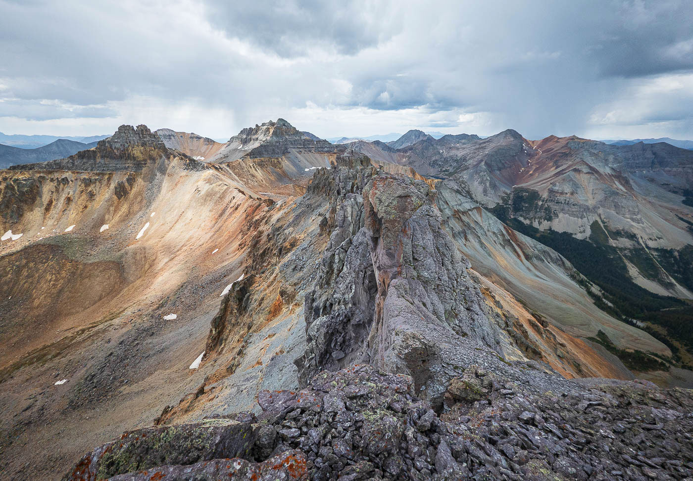
Pilot Knob via Waterfall Creek in San Juan National Forest, CO

Hike Pilot Knob via Waterfall Creek San Juan National Forest, CO

Class 4 9.4 miles 4100 gain 4-6 hrs Out + Back
Effort
Beauty
Personality
Solitude

Pilot Knob via Waterfall Creek GPX Track

I need to offset my substantial website costs somehow! You can download a hike/drive GPX to assist you here. Before sharing my GPX tracks with others, please remember my site is otherwise a free resource.

Sep 4, 2025 — Pilot Knob is a unique 13er at the northern end of a colorful ridgeline housing a string of peaks, which Vermillion Peak and Golden Horn. The consensus is that Pilot Knob is Class 4, but I think it’s on the lower end. The peak is most often reached via Ice Lakes Basin out of Silverton, but we wanted to approach from the north out of Ophir via the Waterfall Creek Trail. This avoided any need to obtain a permit, and also allowed us to see a lesser-visited area. Maybe one day I’ll actually hike the popular Ice Lakes Trail, but I keep approaching peaks in the area via basically any other route available.

Just past the hamlet of Ophir, we parked at a small lone pull-out marked “Day Use Only”, so I’ll assume this hike isn’t possible for backpackers. The trail began by descending along an old mining road, then climbed steadily toward the alpine basins above. Soon, it bent into the valley that holds Waterfall Creek and continued into its open meadows.

Past an easy-to-miss junction, we continued up the Waterfall Creek Trail as it narrowed into singletrack and began to climb in earnest before traversing above a massive cascade into an upper basin. V3 and Ulysses S. Grant Peak loomed above. The trail headed toward a gorgeous waterfall at the head of Waterfall Creek. The trail disappeared completely for a short time, but we found remnants of it as it switchbacked up the slope just to the left of the fall and ascended above it.

Pilot Knob came into view for the first time, its jagged summit poking the sky, which threatened a storm that later chased us off the summit. We entered a grassy basin and took a steep, grassy slope on the west side of the peak in order to gain the north ridge. Ascending directly would likely have been super dangerous and steep. A faint social trail led us up the scree slope, and the Wilson group gave us a stunning backdrop.

We reached the base of Pilot Knob’s sheer north face. This is where the standard approach for Pilot Knob out of the Ice Lakes Basin merges. Here, the terrain turned loose and awful. Staying as high as possible to reach the base of the wall helped, since lower down meant clinging to horrible scree. There was enough of an eroded social trail for us to know this was the right choice.

Just before reaching the southern end of the peak, a steep Class 3 chute appeared, a weakness that led up to the crest. Route-finding became a bit tricky here. Scrambling directly up turned the route into true Class 4 territory, but with careful prodding this portion can be kept Class 3.

Now on the crest, blobby volcanic rock added some cool obstacles. Despite how narrow the ridge was, it rarely felt seriously exposed. One final Class 3/4 boulder guarded the upper ridge. Beyond it, we scrambled along a slanted ledge that pushed briefly into Class 4 terrain. After that came only a short final scramble to the top. Pilot Knob’s colorful summit views and scramble sequence makes it among the best and most unique 13ers, if you ask me.

PEAKS ON HIKE
Elevation (ft) / Prominence (ft)
Peaks on hike
Elevation
Prominence
1
Pilot Knob
13745 ft
410 rise

Hire me or show me some love!

Hire/refer me as a web developer or send me a few bucks if you find my site useful. I'm not sponsored, so all fees are out-of-pocket and my time preparing trip reports is unpaid. I really appreciate it!

Small pull-out for the Waterfall Creek Trail.
Initially the trail ascends using an old mining road.
Entering the valley housing Waterfall Creek. The ridge housing Yellow Mountain seen above.
Past an easy-to-miss trail junction, continuing along the Waterfall Creek Trail as it ascends via singletrack.
View back down the Waterfall Creek basin.
Traversing above the basin. A massive cascade seen ahead.
The trail ascends toward the cascade, passing above steeper terrain.
Beneath some cliffs and up to the drainage above.
Incredible morning view as we ascend a flatter section of trail through gorgeous meadows in the upper basin. Ulysses S. Grant Peak seen above.
Close-up toward the waterfall at the head of Waterfall Creek, seen center. The trail leads to the left of its outcropping.
Waterfall Creek Trail becomes thinner, and eventually becomes too hard to follow.
We managed to find the trail again higher up as we ascend past the waterfall pictured earlier. It switchbacks up the slope to gain the top of the falls.
View back down into the gorgeous meadow-filled drainage as we ascend above the waterfall.
Just above the waterfall, Pilot Knob came into view (center).
View back, colorful water draining into the waterfall.
We ascended via the watercourse to avoid the lumpy terrain on either side.
A shot back, V3 seen above.
Matt looking up at Pilot Knob.
We entered a wide basin and ascended the grassy slope (center) on the west side of Pilot Knob (top left out or frame).
View back into the basin as we near the north ridge of Pilot Knob.
Side-hilling over to the ridgeline. Pilot Knob seen center.
A social trail led tightly up the scree slope.
View back down the ridgeline. The Wilson group seen top left.
Approaching the base of Pilot Knob.
Just below Pilot Knob's sheer north face, view back down the ridgeline.
Loose, horrible terrain traverses just beneath the western base of Pilot Knob.
I recommend getting as high as possible when you can, hugging the base.
View back along the base.
Just before reaching the southern end of Pilot Knob, a steep Class 3 chute leads up a weakness to the crest at the top of the knob.
View back down the weakness.
Some slightly tricky route-finding. You can easily turn this into true Class 4 if not poking around properly for the easiest route.
Now along the ridge crest, a few blobby obstacles force small ups and downs.
Despite how narrow the ridge was, it only felt particularly exposed a couple of times.
View back along the Pilot Knob crest.
A Class 3/4 boulder obstacle. Past this, Chris is seen on a sloped ledge that ventures into Class 4 territory. Then there's just a final scramble to the summit.
Just below the summit, looking back at the narrow portion mentioned above.
Pilot Knob summit, view northeast toward Ulysses S. Grant Peak.
Pilot Knob summit, view east into Ice Lakes Basin.
Pilot Knob summit, view south toward Vermillion Peak, Golden Horn, etc. San Miguel Peak seen on the right.

Hire me or show me some love!

Hire/refer me as a web developer or send me a few bucks if you find my site useful. I’m not sponsored, so all fees are out-of-pocket and my time preparing trip reports is unpaid. I really appreciate it!