Seymour Mountain, Seward Mountain, Donaldson Mountain, Mount Emmons in Adirondack Park, NY

Hike Seymour Mountain, Seward Mountain, Donaldson Mountain, Mount Emmons Adirondack Park, NY

Class 2 20.8 miles 6400 gain 9-12 hrs Loop
Effort
Beauty
Personality
Solitude

Seymour Mountain, Seward Mountain, Donaldson Mountain, Mount Emmons GPX Track

I need to offset my substantial website costs somehow! You can download a hike/drive GPX to assist you here. Before sharing my GPX tracks with others, please remember my site is otherwise a free resource.

Jul 5, 2025 — The Seward group is a cluster of four 46ers set farther west from the other Adirondack High Peaks. They offer less in terms of views, and the somewhat long, boring approach to their base makes them a less appealing objective than many others. Seward Mountain is the gem of this group, both the tallest and most prominent. Donaldson Mountain and Mount Emmons are just two lumps along the ridgeline, unranked peaks feel like questionable additions to the Adirondack 46ers list. Seymour Mountain sits on its own and is often hiked separately from its Seward Range siblings, but I wasn’t about to do the long approach twice, so I just grouped them all together.

I chose a clockwise route so I could get the long, flat old-road walk out of the way first, starting with Seymour Mountain. I began along the Blueberry Trail from the parking area, which was essentially an old road repurposed as a hiking trail. There’s also an equestrian-designated trail paralleling it to the south, clearly marked with signs to keep hikers on track. Past its junction with the equestrian trail, the Blueberry Trail becomes the Ward Brook Truck Trail, which is a long, flat stretch of old road walking. It stayed mostly level for several miles, making for an easy warm-up but not a particularly thrilling one, as it headed toward the northern base of the peaks.

I passed the herd path junction for the Mount Seward Trail, first continuing farther to tackle Seymour Mountain since it’s an out-and-back. Seymour is a typical Adirondack peak hike, complete with boulders everywhere, roots plotting ankle traps, and a couple of scrambles to keep things interesting. Slabs appeared here and there, the kind that look harmless but turn into slides when wet. Higher up, the scenery grew more lush, with moss carpeting the rocks. Seymour’s summit itself wasn’t memorable, so I didn’t linger before heading back down.

Back at the Seward Mountain Trail, the route soon paralleled a creek, with little cascades here and there. The trail mixed in bouldery sections, a few scrambles, and some messy downed trees covering muddy ground. Near the summit, a short cliff forced a detour along its base before a hairpin turn brought me up.

From the top of Seward, I could see the remaining two 46ers along the ridge. The descent was steep, and the trail veered well off the ridge crest, adding unnecessary vertical gain, and I wondered why it wasn’t built to just stick to the crest. The high-elevation forest here was beautiful, so a little extra effort didn’t hurt.

I reached the junction with the Calkins Brook Trail, but first, I needed to tag the other two peaks. A short spur brought me up a few scrambles to Donaldson Mountain, an unremarkable summit. Next, there’s a short descent into a col before the climb up to Mount Emmons, where a series of infamous mud pits began. Mount Emmons feels like the unnecessary side quest of the 46ers: lost in mud and trees, almost invisible on the map, and offering virtually no views. Plus, its low prominence keeps it far from meeting my personal peakbagging rules, placing it near the bottom of my 46er favorites list. I guess it was a quick enough out-and-back, though.

I retraced my steps over Donaldson and picked up the Calkins Brook Trail for my descent, which would allow me to complete the loop. This route down was notably less steep than the ascent to Seward and far less rocky, mostly just forest walking with a few creek crossings. The afternoon light was lovely and I really enjoyed the long walk back. Eventually, the trail crossed Calkins Brook and widened into old doubletrack, meeting the Calkins Brook Truck Trail. It climbed a few hundred feet over a pass (err… “col”, I guess, since this is the northeast) before dropping me back onto the Blueberry Trail, closing out a full day of classic Adirondack shenanigans.

PEAKS ON HIKE
Elevation (ft) / Prominence (ft)
Peaks on hike
Elevation
Prominence
1
Seymour Mountain
4123 ft
1044 rise
2
Seward Mountain
4362 ft
2050 rise
3
Donaldson Mountain
4132 ft
166 rise
4
Mount Emmons
4067 ft
146 rise

Hire me or show me some love!

Hire/refer me as a web developer or send me a few bucks if you find my site useful. I'm not sponsored, so all fees are out-of-pocket and my time preparing trip reports is unpaid. I really appreciate it!

Along the Blueberry Trail from the parking area. It's mostly just an old road repurposed as a trail.
Image 1 from gallery
A junction early on, keep left.
The trail remains mostly flat for the first several miles to reach the northern base of the peaks.
The Blueberry Trail becomes the Ward Brook Truck Trail, and is a long stretch of old road walking.
Junction with the Mount Seward Trail, which I'd be returning to later.
I continued a bit longer on the Ward Brook Truck Trail, then headed south along the Seymour Trail.
The Seymour Trail is about as typical as Adirondack hiking gets: large bolders strewn about, roots sticking out, and a couple of scrambly sections.
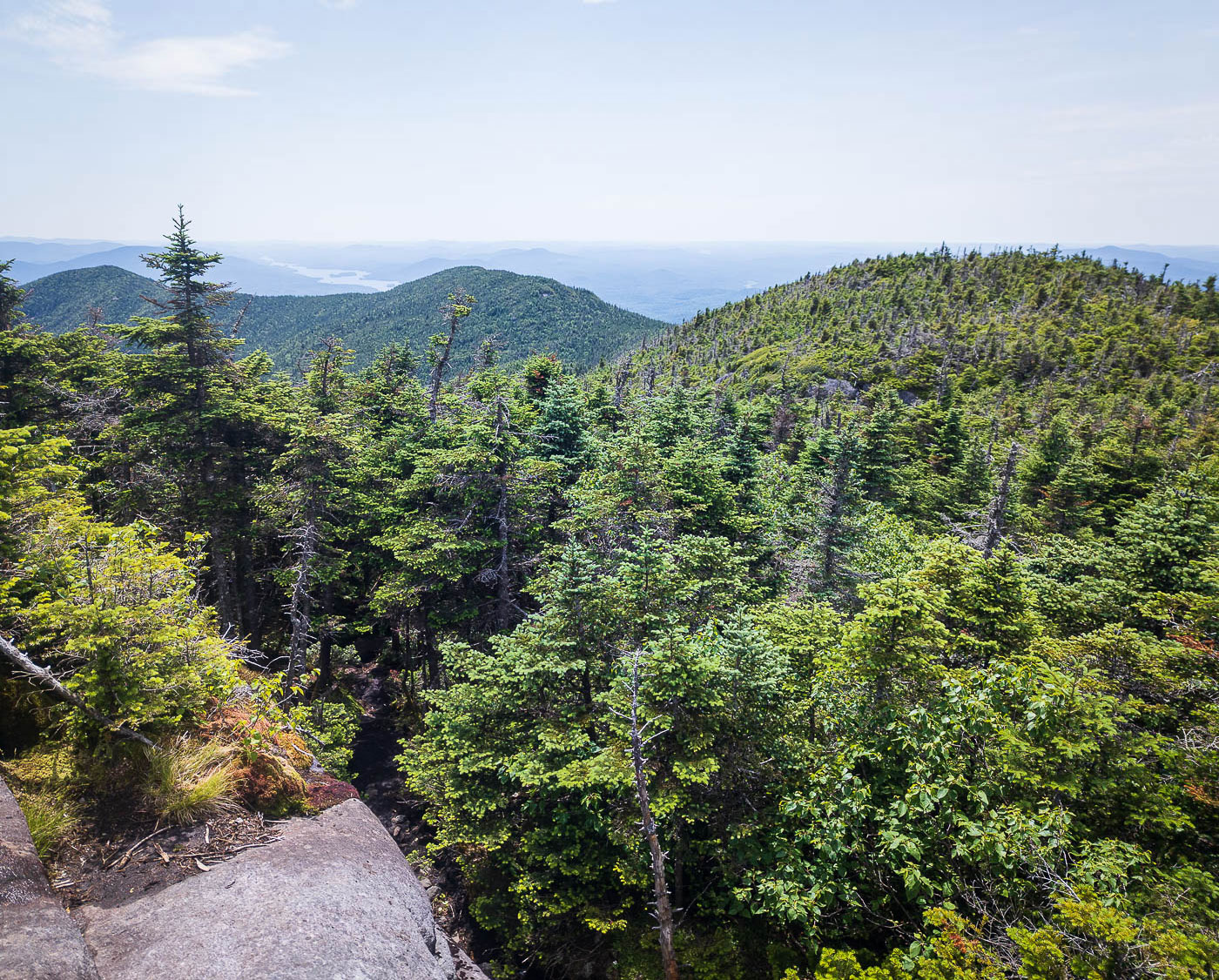
Some slabs along the Seymour Trail.
View back down at a small break in the trees.
Steep trail, lush scenery higher up.
Mosses atop rocks along the Seymour Trail.
Ledges to navigate, ahead.
More rocky terrain as I approach the summit.
Image 14 from gallery
Seymour Mountain summit view.
I backtracked and took the Seward Mountain Trail.
The trail parallels a creek for a while.
Pretty cascade along the way.
Approaching Seward Mountain from this direction is more rugged and steep than if coming from the Calkins Brook Trail, which I used as my descent.
Image 20 from gallery
A viewpoint along the way up the Seward Mountain Trail.
Bouldery hiking.
Bouldery hiking.
Some sections of scrambling.
Often the trail was a bit of a mess.
Another shot back as I near the summit of Seward Mountain.
Image 26 from gallery
A short cliff that requires follow its base and then taking a hairpin turn to overcome.
Seward Mountain summit view.
Onward to the next couple of 46ers, Donaldson Mountain (left of center), and Mount Emmons (far left).
Steep descent off Mount Seward. The trail drops well off the ridge crest, losing extra vertical gain.
More lush high-elevation forest walking.
View back toward Seward Mountain. The trail had dropped down off the ridge toward the center of this photo before reascending to where I'm standing.
Class 2+ to Donaldson Mountain, a 46er that's only a quick spur trail from the main route.
On the way up to Donaldson Mountain.
Horrible section of mud just past Donaldson Mountain on the way to Mount Emmons. There were a few more annoying spots like this along the crest.
View back along the way to Mount Emmons, a view of Seward Mountain poking up.
Some obstacles along the way to Mount Emmons, the peak visible just ahead.
The narrow trail continues through the forest.
Some more typical Adirondack hiking.
Mount Emmons view, seen just before reaching the high point.
Anticlimactic Mount Emmons summit.
I backtracked over Donaldson Mountain and joined the Calkins Brook Trail, which would be my descent route, forming a loop.
Descending via the Calkins Brook Trail.
Mostly just a forested hike with a couple of little creek crossings, and not particularly steep, for Adirondack trail standards.
Crossing Calkins Brook.
The trail becomes an old doubletrack again. I reached a junction with the Calkins Brook Truck Trail, taking it north. It gained a few hundred vertical to go up and over a pass and then met back up with the Blueberry Trail.

Hire me or show me some love!

Hire/refer me as a web developer or send me a few bucks if you find my site useful. I’m not sponsored, so all fees are out-of-pocket and my time preparing trip reports is unpaid. I really appreciate it!