Mount Skylight and Gray Peak via Calamity Brook in Adirondack Park, NY

Hike Mount Skylight and Gray Peak via Calamity Brook Adirondack Park, NY

Class 2 20.4 miles 4400 gain 8-11 hrs Out + Back Jul 2, 2025
Effort
Beauty
Personality
Solitude

Mount Skylight and Gray Peak via Calamity Brook GPX Track

I need to offset my substantial website costs somehow! You can download a hike/drive GPX to assist you here. Before sharing my GPX tracks with others, please remember my site is otherwise a free resource.

Jul 2, 2025 — Mount Skylight and Gray Peak are two Adirondack 46ers usually reached by hiking over Mount Marcy and back, or via the Lake Arnold Trail from the Adirondack Loj. After waffling on which route to take for an embarrassing amount of time, Adam finally suggested we instead approach from the Upper Works Trailhead. This sounded like an excellent plan to me since I’d never come from that direction before. Located far from the busier High Peaks trailheads meant we would have more solitude, too. We also figured if we had time/energy, coming from this direction allowed us to more easily tack on Mount Redfield and Cliff Mountain on our way back, but that ended up not happening.

At the trailhead stands the reconstructed MacNaughton Cottage, the last building left from this historic area. Honestly, I can’t help but think some of the money poured into saving this old relic would’ve gone further if spent on the currently barely-standing pit toilet, a rotting nightmare soaked in decades of excrement. An abridged version of the sign regarding the history of Upper Works reads: Adirondac Upper Works was privately owned since the early 1800s. After rich iron ore was found, a mining community grew around the Adirondack Iron and Steel Company, which produced pig iron for America’s first cast steel. Mining stopped in 1858, and the village was abandoned for 20 years. It was later converted into one of the Adirondacks’ first hunting clubs, then after was mined for lead for a bit, but in 2003 the Open Space Institute protected the 10,000-acre Tahawus Tract, including the former village, to preserve its heritage.

The original trailhead was located a short stroll farther down the gravel road from the new parking area near MacNaughton Cottage. We signed into the register once there and took off along Calamity Brook, a tame hike at first. At a junction, we crossed a wooden bridge over the brook as classic Adirondack territory kicked in, lots of rocks to hop over and maneuver around.

A memorial for David Henderson just off the trail along Calamity Brook caught our attention. What a tough life it would have been out here back then, we noted passively, as we sucked filtered water from our lightweight hydration devices and snorted electrolyte tablets like cocaine. Apparently the guy accident shot himself while on a search for water sources to drive the machinery of the Upper Works. It read: “This monument erected by filial affection, to the memory of our dear father, David Henderson who accidentally lost his life on this spot. 3rd September 1845.”

Passing through the Flowed Lands, serene wetlands tucked into the wilderness, we circled around Flowed Lake. The trail didn’t give us any lake views, so we just kept trucking northward until we reached Lake Colden. Here we took a boardwalk across the south side of the lake with excellent views to the surrounding peaks.

Heading east on the Mount Marcy Trail, we crossed a suspension bridge over the Opalescent River and then continued to parallel it for a while, weaving past beautiful cascades and narrow water sections where the river squeezed between massive hunks of bedrock. At one point, the trail climbed above a unique, narrow gorge.

The trail kept its rocky and tedious charm all the way along Mount Marcy Trail. The section leading up to Lake Tear of the Clouds felt particularly long for some reason, maybe because we were used to enjoying rushing water sounds, which were now absent for this stretch. Lake Tear of the Clouds is a beautiful spot at the base of Mount Marcy, and the unmarked junction to Gray Peak is across the creek on the left. We’d return there later.

We turned our sights on Mount Skylight, steadily making our way up the steep, bouldery trail. There were many parties here, all likely backpackers or those who’d approached via Mount Marcy. We edged closer to treeline, where the views widened dramatically, and then we were hiking within the alpine zone on top of glorious slickrock and with iconic views of Mount Marcy, Mount Haystack, and expansive wilderness elsewhere.

Gray Peak was next, and it’s one of those 46ers that has so little prominence that calling it a peak is totally silly. Normally, under my personal peakbagging prominence rules, I wouldn’t bother hiking it, but somehow, I talked myself into tackling the Adirondack 46ers, so it had to get done. Backtracking to the Gray Peak junction across Feldspar Brook, we tackled the narrow and rugged trail leading up. Along the way, there was a ladder downclimb and some short scramble sections. Before we knew it, we reached a better-than-expected viewpoint toward Mount Skylight and Mount Marcy, and then the summit.

PEAKS ON HIKE
Elevation (ft) / Prominence (ft)
Peaks on hike
Elevation
Prominence
1
Mount Skylight
4926 ft
568 rise
2
Gray Peak
4834 ft
109 rise

Hire me or show me some love!

Hire/refer me as a web developer or send me a few bucks if you find my site useful. I'm not sponsored, so all fees are out-of-pocket and my time preparing trip reports is unpaid. I really appreciate it!

MacNaughton Cottage from the trailhead. The original trailhead is located farther along this gravel road, but the new parking lot is located here.
A short gravel road walk leads to the old trailhead. A wide gravel trail continued for a while.
Paralleling Calamity Brook.
Calamity Brook bridge crossing at a junction with the Indian Pass - Calamity Brook Crossover Trail.
Typical Adirondack rocky trail much of the way past here.
Image 5 from gallery
Along Calamity Brook, a monument to David Henderson that reads "This monument erected by filial affection, to the memory of our dear father, David Henderson who accidentally lost his life on this spot. 3rd September 1845."
Passing campsites around Flowed Lake, in the Flowed Lands. We headed north around Flowed Lake, but didn't have any views of it from the trail.
Crossing the south side of Lake Colden.
Mount Colden above, view north toward Lake Colden.
Onward East along the Mount Marcy Trail, at a suspension bridge over the Opalescent River.
Mount Marcy Trail parallels the Opalescent River.
Cascades along the river.
A narrow section in the watercourse.
Image 14 from gallery
The trail climbs above a narrow, gorgeous portion with swiftwater below.
Image 16 from gallery
View down into this amazing feature.
Continuing along the rocky Mount Marcy Trail.
Image 19 from gallery
Located near the junction with the Mount Redfield Trail and a campgroun, lots of detailed signs.
View back as we ascend along Feldspar Brook. This section felt like it took forever for some reason.
Lake Tear of the Clouds. The junction with Gray Peak is unmarked, but located on the left across the creek.
Heading up to Mount Skylight.
View back as we make progress up to the summit, Mount Marcy in the distance.
Nearing tree line.
Nearing tree line.
Wider shot back toward Mount Marcy (right), Mount Colden and Algonquin Peak (back left).
Nearing the summit of Mount Skylight.
Close-up back along the trail toward Mount Colden and Algonquin Peak.
Mount Skylight summit, view toward Mount Marcy (left) and Mount Haystack (right).
Mount Skylight summit, view west.
Mount Skylight summit, view south.
Back at the junction with Gray Peak, seen across Feldspar Brook.
Narrow, rugged trail to Gray Peak.
A ladder downclimb along the way up, Gray Peak seen top center.
Some scrambling up various features.
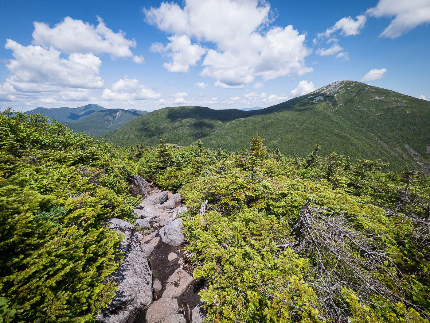
A nice viewpoint toward Mount Skylight along the way to the summit of Gray Peak.
Gray Peak summit, view toward Mount Marcy.

Hire me or show me some love!

Hire/refer me as a web developer or send me a few bucks if you find my site useful. I’m not sponsored, so all fees are out-of-pocket and my time preparing trip reports is unpaid. I really appreciate it!