Giant Ledge and Panther Mountain in Catskill Park, NY

Hike Giant Ledge and Panther Mountain Catskill Park, NY

Class 2 6.6 miles 2000 gain 3-5 hrs Out + Back Jul 7, 2025
Effort
Beauty
Personality
Solitude

Giant Ledge and Panther Mountain GPX Track

I need to offset my substantial website costs somehow! You can download a hike/drive GPX to assist you here. Before sharing my GPX tracks with others, please remember my site is otherwise a free resource.

The Giant Ledge and Panther Mountain hike is one of the more popular trails in New York’s Catskills, famous for its series of rock ledges that peek out over the rolling landscape. It’s a relatively short outing, though you can extend it by continuing north along the ridgeline to another trailhead in Panther Mountain Park, though I opted to turn back after reaching the summit.

I started at the Giant Ledge Trailhead, tucked into the elbow of a hairpin on Oliverea Road. The trail eased me into the hike with a gentle climb through typical lower-elevation forest. A few rocky stretches along the Phoenicia–East Branch Trail led to a saddle on Panther Mountain’s south side.

Once on the ridgeline, the trail wove around several outcroppings before reaching the famed Giant Ledge. The open ledges offered sweeping views eastward across mountains and valleys.

Heading north, the trail dipped a few hundred feet before climbing toward Panther Mountain. The summit itself was unmarked, so I wandered a bit until I found a final viewpoint, confident I’d reached the high point, and then turned back.

PEAKS ON HIKE
Elevation (ft) / Prominence (ft)
Peaks on hike
Elevation
Prominence
1
Panther Mountain
3726 ft
963 rise

Hire me or show me some love!

Hire/refer me as a web developer or send me a few bucks if you find my site useful. I'm not sponsored, so all fees are out-of-pocket and my time preparing trip reports is unpaid. I really appreciate it!

Starting from the Giant Ledge Trailhead.
An overly constructed bridge over a creek shortly after starting the hike.
Rocky, wide section of trail up to the saddle.
On the saddle on the south side of Panther Mountain. I headed north.
Along the Panther Mountain Trail, generally leading north.
Rockier sections along the trail.
View back down at stairs constructed up the slope.
Nearing the Giant Ledges.
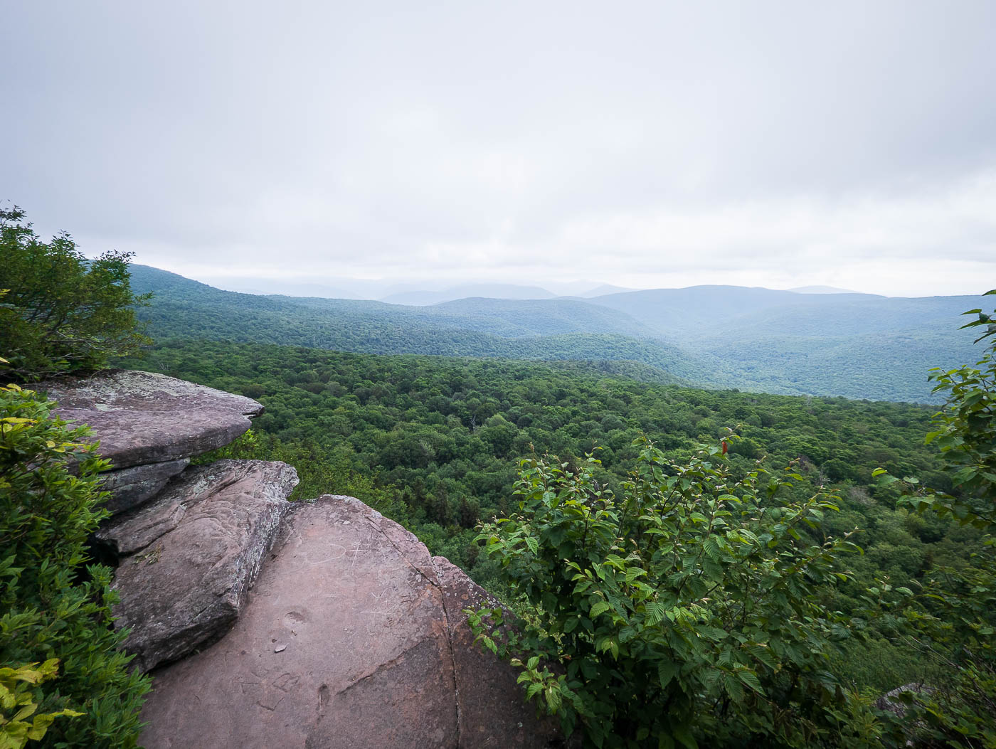
The featured Giant Ledge, view east.
More lookout points along the way to Panther Mountain.
Descending briefly to a saddle with Panther Mountain.
Pretty forested setting with some small outcroppings on the sides of the trail.
Image 12 from gallery
Ascending to Panther Mountain.
I wasn't sure where the true summit was, so I just walked along the ridge crest for a while.
A viewpoint along the way.
Panther Mountain Trail.
A viewpoint where I decided to turn around along the ridgeline, confident I'd reached the summit.

Hire me or show me some love!

Hire/refer me as a web developer or send me a few bucks if you find my site useful. I’m not sponsored, so all fees are out-of-pocket and my time preparing trip reports is unpaid. I really appreciate it!