Byers Peak, Bills Peak, Ptarmigan Peak Loop in Arapaho and Roosevelt National Forest, CO

Hike Byers Peak, Bills Peak, Ptarmigan Peak Loop Arapaho and Roosevelt National Forest, CO

Class 2 16.2 miles 5600 gain 6-8 hrs Loop
Effort
Beauty
Personality
Solitude

Byers Peak, Bills Peak, Ptarmigan Peak Loop GPX Track

I need to offset my substantial website costs somehow! You can download a hike/drive GPX to assist you here. Before sharing my GPX tracks with others, please remember my site is otherwise a free resource.

Aug 23, 2025 — As a prominent 12er with a trail to its summit, Byers Peak a fairly popular summit with excellent summit views, located near Fraser, Colorado. Without knowing much about the Byers Peak Wilderness and with a forecast that basically guaranteed rain (which never actually came), I set out intending simply to reach Byers Peak via the Byers Peak Trail (#12) and then head back. I ended up extending my hike significantly, traversing over to Bills Peak and then up to Ptarmigan Peak and Bottle Peak.

Portions of the trail lie within the Fraser Experimental Forest, so there are some camping restrictions in the area. This also includes the drive in, which leads through the long-term research site where roadside camping is not permitted. The road is in great shape except for the last mile where it becomes rockier and possibly not suitable for passenger vehicles.

The Byers Peak Trail begins at a locked gate across an old forest road. There’s no designated parking lot, but there are a few tight pullouts just past the trailhead. When I returned later after my hike, only about half of them were occupied, so I don’t think parking is an issue if you don’t arrive early.

The first few miles follow a switchbacking road, leaving not much to comment on except that most people seem to prefer biking this portion rather than hiking it. There’s even a bike rack at the start of the singletrack for these clever folks. I, however, made the ascent on foot.

Immediately upon reaching the start of the singletrack, the trail gently ascended toward the northeast ridge of Byers Peak. The foliage was dense and lush, and the views began to open up. Once on the ridge, the trail steepened, and as the trees thinned into tundra, the summit came into view. A gorgeous section of trail climbs up the ridge crest, a thin line carved into alpine grasses. Just below the summit is a short stretch of rocky hiking, barely Class 2.

The summit views from Byers Peak are wonderful. Despite being only a 12er, it’s the most prominent peak in the area. I had fully expected to turn back here, but the inspiring-looking ridge traverse toward Bills Peak, and the lack of any threatening clouds, made the decision to continue obvious.

The tundra stroll from Byers Peak down to the saddle was straightforward, with only a short section of rock-hopping. At the saddle, the terrain became slightly more tedious as the ridge narrowed briefly into a Class 2+ section, which continued for the first hundred or so feet up Bills Peak. Beyond that, it was mostly hiking on a mix of tundra and boulders to the summit.

From the summit of Bills Peak, I looked back at the route I’d just taken and decided I had little interest in going back up and over Byers Peak. Fortunately, I had service and could check for other trails nearby. I was happy to find I could turn the route into a satisfying loop. I dropped north off Bills Peak and stumbled onto the Saint Louis Divide Trail, another pleasant singletrack etched into the tundra. To my left stretched a gentle slope and to my right, an eroded face with various pinnacles. Thrilled with the discovery, I frolicked down the trail. While generally easy to follow, it briefly disappeared before joining the Keyser Ridge Trail on top of a small knoll, then reappeared as it reached the junction with the Lake Evelyn Trail.

I descended the excellent trail to Lake Evelyn, a calm body of water surrounded by conifers, then continued north. The singletrack became an old roadbed at some point along the way, eventually leading to the Lake Evelyn Trailhead.

In hindsight, I could have started my loop at the Lake Evelyn Trailhead instead of the Byers Peak Trailhead. Doing so would have saved around 800 feet of elevation gain and cut out the less scenic gravel road walk. I’m not sure about the road quality along Lake Evelyn Road, but it’s a viable alternative starting point (39.89364, -105.95649). For efficiency, it would probably make the most sense to begin at Lake Evelyn, go clockwise as I did, and start with Ptarmigan Peak first. That route would allow you to follow the ridgeline, connect via the B&B Trail, and link up with the Byers Peak Trail, saving both mileage and vertical gain. I’ve marked the Lake Evelyn Trailhead as an alternate parking option on my attached map.

Anyway, I continued from the Lake Evelyn Trailhead along the gravel road Bottle Pass Trail, leaving it for the steeper singletrack Bottle Peak Trail. This took me up to the saddle separating Ptarmigan Peak and Bottle Peak, just above treeline. I hiked up the tundra to gain Ptarmigan Peak, then made my way over to Bottle Peak. The views toward Byers and Bills on the way down from Bottle Peak were fantastic. I dropped east along the Bottle Pass Trail down to the Byers Peak gravel road and returned to the trailhead.

PEAKS ON HIKE
Elevation (ft) / Prominence (ft)
Peaks on hike
Elevation
Prominence
1
Byers Peak
12808 ft
1281 rise
2
Bills Peak
12702 ft
619 rise
3
Ptarmigan Peak
11777 ft
877 rise
4
Bottle Peak
11603 ft
280 rise

Hire me or show me some love!

Hire/refer me as a web developer or send me a few bucks if you find my site useful. I'm not sponsored, so all fees are out-of-pocket and my time preparing trip reports is unpaid. I really appreciate it!

Byers Peak Trailhead.
After a gravel road walk, I reached the start of the singletrack.
Byers Peak Trail singletrack.
Byers Peak seen ahead along the ridgeline.
View back, Ptarmigan Peak and Bottle Peak on the left. The Byers Peak Trailhead is below in the center somewhere.
Byers Peak Trail though the tundra.
Close-up toward the summit.
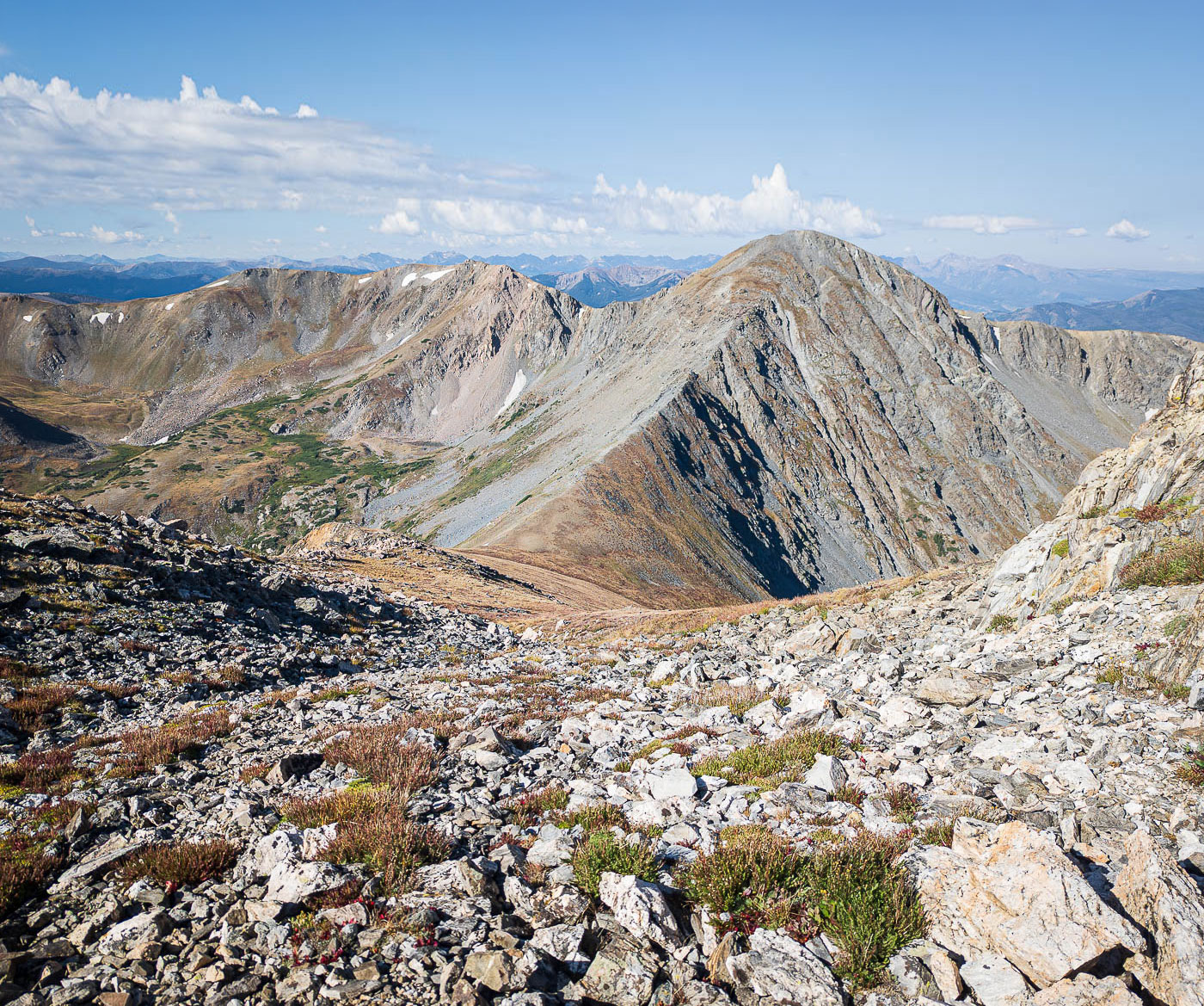
Byers Peak false summit ahead.
Barely Class 2 section to reach the false summit.
Byers Peak summit ahead on the left.
Byers Peak summit, view south. Bills Peak right of center.
On my way down to the saddle.
View back at some Class 2 along a scrambly bit at the saddle.
A bit more Class 2 just past the saddle, starting up Bills Peak.
Nearing the top of Bills Peak, wide shot back toward Byers Peak.
Bills Peak summit, view south.
Bills Peak summit, view north, toward the direction I continued my hike. Ptarmigan Peak seen top right, the next peak on my loop.
Looking back toward Bills Peak.
Pinnacles along the eroded east rim.
A wonderful tundra trail stroll.
The trail leads up the knoll on the right, then down to the saddle left of center.
View back toward Byers Peak (left) and Bills Peak (right).
Lake Evelyn seen left, Ptarmigan Peak right.
Descending the Lake Evelyn Trail.
Lush greenery along the trail.
Lake Evelyn.
Lake Evelyn.
A bit more singletrack on the way down from Lake Evelyn.
Then an old roadbed leads the rest of the way to the Lake Evelyn Trailhead.
Heading up the Bottle Pass Trail.
Junction with the Bottle Peak Trail, which I took on the left.
Bottle Peak Trail.
Bottle Peak Trail.
View back toward Byers and Bills.
Saddle, starting up to Ptarmigan Peak.
Ptarmigan Peak, view toward Bottle Peak (left), and Byers/Bills (right).
After a short trip up to Bottle Peak, this is the view down its south ridge.
Bottle Pass Trail back down to the Byers Peak Trail.

Hire me or show me some love!

Hire/refer me as a web developer or send me a few bucks if you find my site useful. I’m not sponsored, so all fees are out-of-pocket and my time preparing trip reports is unpaid. I really appreciate it!