Black Hawk Mountain and Granite Dome in Stanislaus National Forest, CA

Hike Black Hawk Mountain and Granite Dome Stanislaus National Forest, CA

Class 3 22.9 miles 5900 gain 9-12 hrs Loop Jul 29, 2025
Effort
Beauty
Personality
Solitude

Black Hawk Mountain and Granite Dome GPX Track

I need to offset my substantial website costs somehow! You can download a hike/drive GPX to assist you here. Before sharing my GPX tracks with others, please remember my site is otherwise a free resource.

The granite blanket surrounding Black Hawk Mountain and Granite Dome piqued my interest, and despite the somewhat long drive, I couldn’t resist checking out this area. Since I was dayhiking, I could park at the Kennedy Meadows Resort & Packstation, but overnight hikers need to use the designated lot about half a mile back.

The hike began with a mile-long stretch of dirt road closed to unauthorized vehicles, passing through Kennedy Meadow at one point. I soon reached the official trailhead and started up the wide Relief Reservoir Trail, initially annoyingly sandy and seemingly paved with horse manure. A bridge crossed the Middle Fork of the Stanislaus River along the Relief Reservoir Trail, dramatically carved into a cliff face with water rushing in the gorge below. A couple of bridges were constructed over the gorge.

As I climbed, the river fell away and the forest gradually opened to expansive views. I passed some historic mining remains on the side of the trail and eventually reached the northern reaches of the Relief Reservoir. The Huckleberry Trail wrapped around its eastern shore, high enough to offer nice views. Beyond the lake, Granite Dome poked up on the horizon.

The Huckleberry Trail progressed around a brushy slope and wiggled up a steeper portion of forested trail. The trail contoured for a while beneath some steep cliff faces, with occasional views toward the beautiful landscape of broad granite slabs I’d be hiking within soon, including the ridgeline from Black Hawk Mountain to Granite Dome.

Unsure when to leave the trail and start into the unknown, I crossed Summit Creek at a narrow section so I didn’t have to take my shoes off. Almost immediately I stepped into a granite wonderland en route to Lewis Lakes. Slickrock led upward with only minor obstacles. I skirted a small forest’s edge, favoring the smooth granite whenever possible. Clear pools and small cascades soon appeared as I followed the main drainage, where water-carved channels and polished nooks made the hike really engaging. It was all mostly easy walking with an occasional Class 2 or mild Class 3 move.

I reached the lowest Lewis Lake, and ahead of it was the drainage I planned to take to reach Black Hawk Mountain. This drainage required some boulder-hopping, and I found myself pulling a few Class 3 moves. There were a couple of surprisingly cool waterfalls tumbling off the granite. Staying left of a brushy flat, I stuck to open rock until a final waterfall marked the head of the drainage. More Class 2 brought me to a viewpoint of Black Hawk Mountain.

Reaching the base of my first summit meant weaving through a short maze of small cliffs, then ascending its loose northwest volcanic slope, a short section that was totally different in character from the granitic ascent so far. From the grassy summit I looked east toward Tower Peak, down to Black Hawk Lake and Lewis Lake, and all the way back to Relief Reservoir where my morning began.

The ridgeline connecting Black Hawk Mountain to Granite Dome has two large humps and a ton of granite to navigate. Some scrambly sections kept it exciting, but with just a little route-finding I kept the going Class 2, though there was plenty of it. Both humps had their own personality and I found this whole section totally unique and enjoyable.

Past the two humps, I navigated around a few granitic clusters, ascended a ramp, and found my way to the high point of Granite Dome. After soaking in the views, I backtracked to locate a less cliffy descent than attempting a more direct route down. Dropping to the uppermost Lewis Lake, I aimed for a weakness on its far side and found a handy ledge that eased me onto a safe granite slope, though for a moment I worried I might get cliffed out.

The best view of the day was down toward the largest Lewis Lake, nestled within the granite beneath the ridgeline I’d traversed. I descended broad Class 2 slabs and worked around a few small cliff bands that required short, simple Class 3 moves. Eventually I rejoined my original ascent route through the granite and headed back toward the trailhead.

PEAKS ON HIKE
Elevation (ft) / Prominence (ft)
Peaks on hike
Elevation
Prominence
1
Black Hawk Mountain
10329 ft
983 rise
2
Granite Dome
10325 ft
571 rise

Hire me or show me some love!

Hire/refer me as a web developer or send me a few bucks if you find my site useful. I'm not sponsored, so all fees are out-of-pocket and my time preparing trip reports is unpaid. I really appreciate it!

Kennedy Meadow, shortly after leaving the trailhead along a dirt road that has driving restrictions.
I reached the official trailhead after a bit of walking along the a restricted dirt road.
Bridge over the Middle Fork Stanislaus River.
The Relief Reservoir Trail was carved into the cliff face.
View back along the Relief Reservoir Trail.
Ascending adjacent to the watercourse.
A waterfall off the side of the trail.
A short forested walk leads to this junction. I continued to Relief Reservoir.
View back as I ascend above the trees.
Relief Reservoir. The Huckleberry Trail wraps around its east side.
View back along the Huckleberry Trail.
Past the reservoir, a nice view toward Granite Dome.
The Huckleberry Trail wraps around the brushy slope.
Some cliff faces along the east side of the trail.
And lots of views of the granite to come to the west. Black Hawk Mountain is up there top left somewhere out of view.
I crossed Summit Creek, leaving the trail to enter the granitic wonderland and heading toward Lewis Lakes.
Up some initial slickrock with minimal obstacles lower down.
View north toward the trail (within the trees) and pretty volcanic sliffs.
I skirted the edge of the forest, choosing slickrock when possible.
Pretty water features began getting introduced.
Heading up the main drainage toward Lewis Lakes.
Some really cool water-carved features amongst the granite.
View back at my progress up the granitic slope, mostly walking with a few Class 2 (and maybe some very easy Class 3 moves).
There were a bunch of little nooks to explore on the way up.
Image 24 from gallery
Image 25 from gallery
The lowest of the Lewis Lakes on the left.
Approaching the boulder-hoppy drainage to ascend toward the largest of the Lewis Lakes.
I just ascended the boulders ahead, a Class 3 move here and there.
A surprisingly cool waterfall tumbling off the granite.
View back.
View back.
I continued on the left of this brushy flat section, taking the granite instead.
Close-up of the remaining drainage, with a waterfall at its head.
Class 2/3 up the granite below the waterfall.
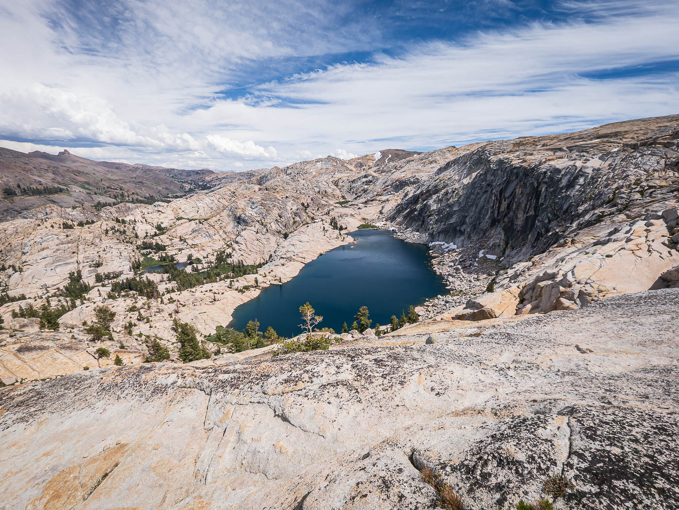
A view back at my progress. The largest Lewis Lake is seen center. On my way down later I'll be on the cliffs above it.
Black Hawk Mountain comes into view. There was a bit of a maze of small cliffs to navigate reach its base.
My chosen drainage to ascend toward the peak.
Wildflowers at the base of Black Hawk Mountain.
View back down as I ascend the loose northwest slope of Black Hawk Mountain. The drainage I came up is seen left.
Black Hawk Mountain summit, view east.
Close-up east. Tower Peak seen far right.
Black Hawk Lake below, Lewis Lake far right, Relief Reservoir where I came from top right.
Onward along the ridgeline to Granite Dome, seen center.
View back toward Black Hawk Mountain. Molo Pinnacle seen on the left.
There are two notable humps along the traverse, the first one seen ahead. There are some scrambly obstacles, but you can easily keep the going Class 2 with some route-finding. The terrain up here was incredible, and the views expansive.
View back from the first of the two ridgeline granite humps.
Second hump ahead, requiring another drop. A cliff on the left meant I needed to ascend farther on the right.
View back toward the first hump.
A cute puddle along the ridgeline, framed by granite.
Continuing the ascent to Granite Dome. Ahead is a small cliff with many options to overcome it, but I chose to ascend using a low-angle gully at the base of the orange cliff on the right.
Granite Dome false summit ahead.
View back toward Black Hawk Mountain (right). Molo Mountain seen left.
Granite Dome seen left. I wrapped around the first granite cluster to locate an ascent ramp.
Class 2 ramp and then some light route-finding to reach the high point.
Granite Dome summit, view north toward Sardella Lake (right), Iceland Lake (left), and Relief Reservoir (top left).
Close-up toward Iceland Lake and Relief Reservoir.
Granite Dome summit, view south.
I backtracked a bit from Granite Dome in order to locate a less cliffy-looking descent option. The uppermost Lewis Lake is seen on the right. I dropped down to it, but chose to do some using the terrain on the left.
View back toward my descent from the ridgeline east of Granite Dome.
Upper Lewis Lake. I headed up to the weakness seen center.
View back from the weakness toward Upper Lewis Lake and Granite Dome.
Fortunately, there was a ledge that permitted me to gain the granite slope that would lead me down. I thought I might have gotten cliffed out.
Lewis Lake from the cliffs above. No, my shot isn't tilted, this is actually the wild angle of the granitic slope.
I took the drainage seen center earlier to reach Black Hawk Mountain (top center).
Class 2 granite descent slope.
View back up toward an obstacle on my way down the slope.
There were many obstacles along the way down my chosen slope, but nothing exceeding a short/simple Class 3 move to overcome small cliff bands. Eventually I met back up with my ascent route through the granite.
On my way back, a shot toward the granitic ridgeline with better lighting.

Hire me or show me some love!

Hire/refer me as a web developer or send me a few bucks if you find my site useful. I’m not sponsored, so all fees are out-of-pocket and my time preparing trip reports is unpaid. I really appreciate it!