Class 4 13.1 miles 4200 gain 6-8 hrs Out + Back
Effort
Beauty
Personality
Solitude

Heisshorn and El Punto GPX Track

I need to offset my substantial website costs somehow! You can download a hike/drive GPX to assist you here. Before sharing my GPX tracks with others, please remember my site is otherwise a free resource.

Sep 2, 2025 — Heisshorn and El Punto are a pair of Colorado 13ers in the fantastic Cimarron Range, located north of the well-known 14ers Wetterhorn and Uncompahgre. The standard route follows the Middle Fork Trail #227, which parallels the Middle Fork Cimarron River for most of its length. Any car can likely reach the trailhead, though passenger vehicles may need to use caution over a few dips.

The trail climbed steadily through forest and open stretches of meadow. It was a beautiful morning hike with the impressive cliffs surrounding Precipice Peak to the west providing a striking backdrop. The trail steepened past the junction with Porphyry Basin but mellowed again as the trees thinned into tundra.

As we neared the base of Heisshorn and the trail climbed more earnestly again, the scenery only improved. We reached the saddle separating our two peaks for the day. Here, we left the trail and continued west toward Heisshorn first. Countless sheep were grazing across the tundra below at the base of Wetterhorn Peak, making an assortment of silly bleats.

Heisshorn is rated somewhere between Class 3 and 4, depending on who you ask. It has some exposure and a short section of loose rock plates that push it into that range, so I’d call it Class 3+. There aren’t really any moves that demand true Class 4, but care is required due to the abundance of loose rock. After an initial slope, we began scrambling up loose Class 2 talus, staying along the crest as much as possible. It might be tempting to stay left beneath the steeper-looking sections, but that only leads to a harder scramble later to regain the crest.

A narrow ridge teetering on knife-edge status offered some cool moves and an amazing perspective of the summit ahead, intimidating from this angle for sure, There wasn’t anything too difficult, but enough to keep it engaging. Before long, we reached the base of the Class 3/4 section, where solid handholds were not particularly easy to find, since the blocks felt like they might all give way, though none did.

Past the crux, we traversed left of the steep crest, following a ledge that offered a safer way around the most vertical section. A final bit of Class 3 led us to the summit. Coxcomb Peak stood directly ahead, surrounded by the colorful volcanic chaos of Dike Ridge.

We descended from Heisshorn and started up toward El Punto next, the high point being the leftmost large tower in the cluster surrounding the summit. The rolling tundra ridge to reach the peak’s base included a few short Class 2 sections before we contoured over to a steep, loose screen slope. Here we found a social trail that led us up to El Punto’s north side.

We wrapped right around an initial outcropping, then followed a short stretch of Class 2 and some Class 3 to reach a wide, flat area resembling a castle battlement. A short, narrow walkway led to the start of the crux. More Class 3 and a final vertical Class 4 move brought us to the summit. From the top of El Punto, we debated which block was actually higher. The farther one looked like the true summit, though reaching it was a bit exposed.

We closed our little loop by descending along the tundra slope and rejoining the Middle Fork Trail.

PEAKS ON HIKE
Elevation (ft) / Prominence (ft)
Peaks on hike
Elevation
Prominence
1
Heisshorn
13418 ft
463 rise
2
El Punto
13319 ft
319 rise

Hire me or show me some love!

Hire/refer me as a web developer or send me a few bucks if you find my site useful. I'm not sponsored, so all fees are out-of-pocket and my time preparing trip reports is unpaid. I really appreciate it!

Starting along Middle Fork Trail.
Gorgeous scenery as we parallel the Middle Fork Cimarron River.
Close-up toward the cliffs to the west.
View back along the trail.
Trail junction with the Porphyry Basin Trail along the way.
More beautiful cliffs to the west.
View back as we make our way through thinning trees and up to treeline.
Open meadows higher up. Heisshorn seen poking up on the left.
View back through the beautiful meadows.
Coxcomb Peak seen right, Heisshorn left.
Another shot back at the open meadows.
Ascending to the saddle separating Heisshorn and El Punto. El Punto seen above my friends' heads.
Another shot back as we make our way up to the saddle. Fortress Peak and Precipice Peak seen above Tom.
Starting up to Heisshorn from the saddle.
View back toward the saddle. El Punto seen left, Uncomphagre right. Lots of adorable sheep on the slope.
Higher up, another shot back at our progress.
Close-up of Coxcomb and Redcliff.
Class 2/2+ starts pretty abruptly after the tundra slope section.
Along the ridge crest, past the initial loose bouldery scramble.
View back down at the narrow ridge.
Wider shot back.
Wider shot back.
The crest narrows significantly. Wetterhorn Peak seen left.
Image 22 from gallery
Some fun moves along the crest.
Nearing the base of the Class 3/4 section.
Scrambling Class 3/4.
View back at the crux, which is a bit exposed, but has enough solid holds, even though the large blocks feel like they might pop out.
Past the crux, we navigated left of the steep crest.
A ledge leads more safely around the very steep crest.
Class 3 to the summit.
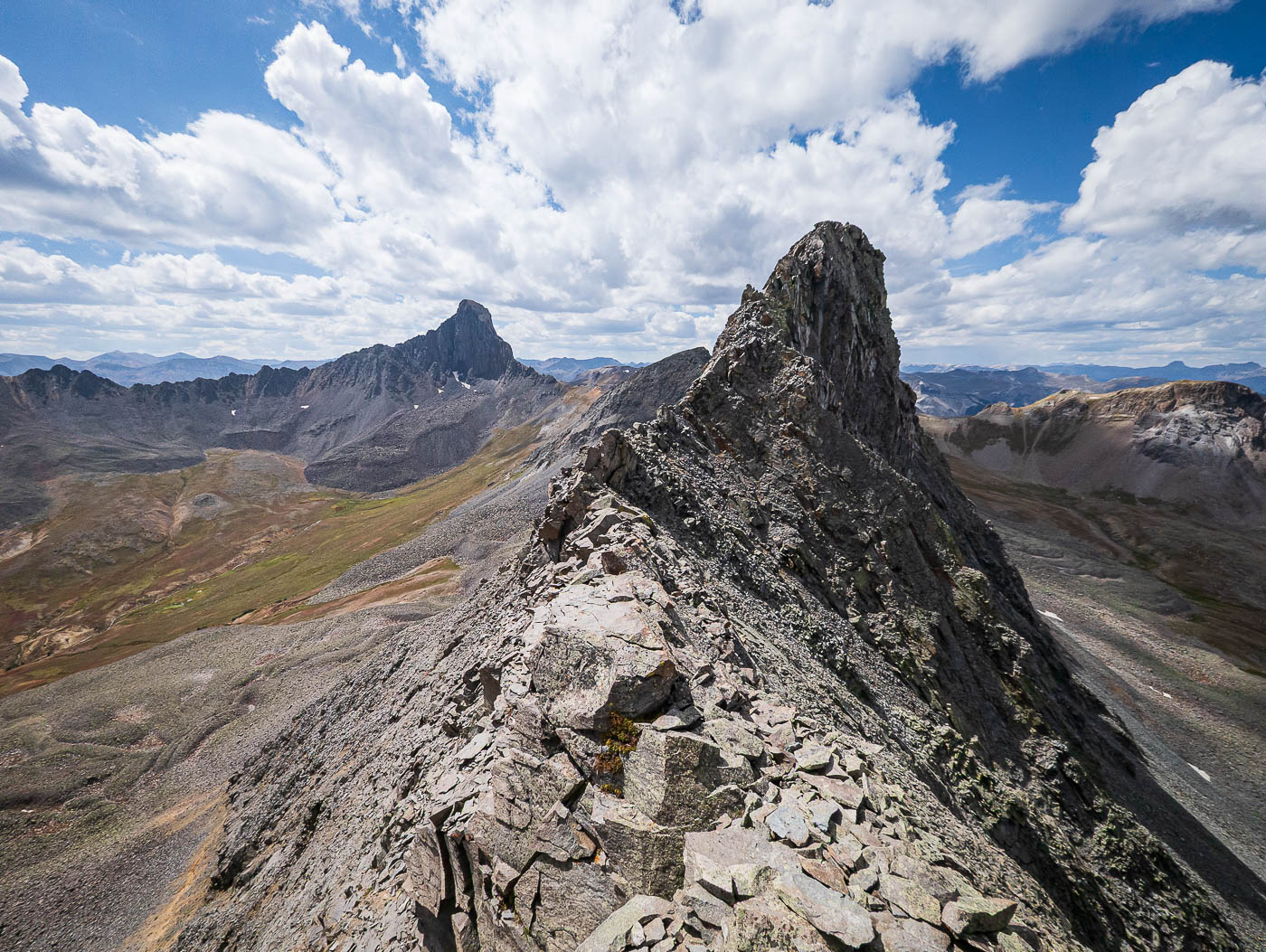
Heisshorn summit, view down the valley we hiked up.
We descended from Heisshorn and headed up toward El Punto next. The high point is seen far left. Despite appearing all tundra, there was some Class 2 along the way to its base.
View back toward Heisshorn (left of center) as we take a social trail up a steep, loose scree slope.
The social trail led us to the north side of El Punto. Here are now just below the summit of El Punto. We wrapped to the right around the initial outcropping seen ahead.
Some Class 2 to get around the outcropping.
Class 3.
Class 3.
A very cool feature: a wide, flat section with a narrow walkway. El Punto seen left.
Class 3.
Class 3.
And one Class 4 move to gain the summit.
El Punto summit. I believe the high point is the farther block (where I took this photo from), but maybe not. It's exposed to reach this point.
View toward Precipice Peak.
Tundra walk down to regain the Middle Fork Trail.

Hire me or show me some love!

Hire/refer me as a web developer or send me a few bucks if you find my site useful. I’m not sponsored, so all fees are out-of-pocket and my time preparing trip reports is unpaid. I really appreciate it!