Mount Alice and Tanima Peak in Rocky Mountain National Park, CO

Hike Mount Alice and Tanima Peak Rocky Mountain National Park, CO

Class 2 19.2 miles 5400 gain 8-11 hrs Loop
Effort
Beauty
Personality
Solitude

Mount Alice and Tanima Peak GPX Track

I need to offset my substantial website costs somehow! You can download a hike/drive GPX to assist you here. Before sharing my GPX tracks with others, please remember my site is otherwise a free resource.

Aug 24, 2025 — Amanda and I headed into Wild Basin before the timed entry permits kicked in for the day. As of writing this, no timed entry permit is required if entering before 9am. We started along the lengthy forested approach from the Wild Basin Trailhead, nearly six miles of trees and limited views before treeline finally opened things up.

We followed the Wild Basin Trail to the Thunder Lake Trail, all of it wide and pleasantly gradual. Most folks tackle Mount Alice from the south via the Boulder-Grand Pass Trail, but we decided to spice things up and come from the north. That way, we’d get to scramble along the scenic Hourglass Ridge and make a partial loop. We decided to descend the standard route later, which would allow us to also tack on Tanima Peak.

Mount Alice’s northern route required we us to leave the Thunder Lake Trail and follow the Lion Lake Trail, which was in excellent shape, but did mean a noticeable increase in steepness and effort. We popped above treeline at Lion Lake #1, where Chiefs Head Peak’s hulking southern face loomed overhead. With the wildly unpredictable weather Colorado has had all week, we thought it best to skip Chiefs Head Peak, tempting as it was, and just head up to Mount Alice instead and save that other 13er for another day.

The Lion Lake Trail got trickier to follow as it wound through meadows and past waterfalls, eventually fading near Snowbank Lake. At that point, we veered west up a bouldery ascent along the lengthy and prominent sloped ridge leading to Hourglass Ridge, the divider between Mount Alice and Chiefs Head. The climb was a mix of grassy and rocky stretches.

Hourglass Ridge gave us fantastic views and a viewpoint of Mount Alice’s Class 2+ northern route, as well as its intimidating and sheer technical east face. The baby scramble route we took was steep but manageable, with a few optional Class 3 moves if you’re feeling like adding some fun (or, in our case, trying to beat an incoming storm). There were two possible high points on Alice’s summit ridge, so naturally, we tagged both before dropping south along the broad, tundra-covered slope. A few rocky patches added some texture to the otherwise mellow stroll down to Boulder-Grand Pass, the saddle separating Mount Alice from Tanima Peak.

Tamina Peak is a 12er composed mostly of tundra walking, but included a short and interesting Class 2+scramble to the summit. The views toward Isolation Peak and the surrounding basins were really lovely, and we soaked in the views for a bit before descending back to Boulder-Grand Pass.

From above, the descent from Boulder-Grand Pass looks pretty nasty, but after about 50 feet of loose junk, we found a Class 2 option that cut left over a rib and dropped us onto a more solid slope, much better than the slippery hardpan straight down. If we’d ascended this way (the standard route) from Lake of Many Winds, the route would’ve been more obvious.

We picked up the Boulder-Grand Pass Trail, a really stunning section of the hike, which led down to Thunder Lake below. At a lean-to on the east side of Thunder Lake, we picked up the Thunder Lake Trail, which surprised us with an ascent of a few hundred feet, before descending gradually to the junction with the Lion Lake Trail we’d taken earlier.

PEAKS ON HIKE
Elevation (ft) / Prominence (ft)
Peaks on hike
Elevation
Prominence
1
Mount Alice
13317 ft
846 rise
2
Tanima Peak
12432 ft
380 rise

Hire me or show me some love!

Hire/refer me as a web developer or send me a few bucks if you find my site useful. I'm not sponsored, so all fees are out-of-pocket and my time preparing trip reports is unpaid. I really appreciate it!

Wild Basin Trailhead.
Wild Basin Trail along North St. Vrain Creek.
Taking the Thunder Lake Trail.
After much forested walking, we reached the Lion Lake Trail junction, which we took on the right.
Lion Lake Trail.
Lion Lake Trail.
View back along the Lion Lake Trail.
We emerged from the trees at Lion Lake, Chiefs Head Peak seen top left.
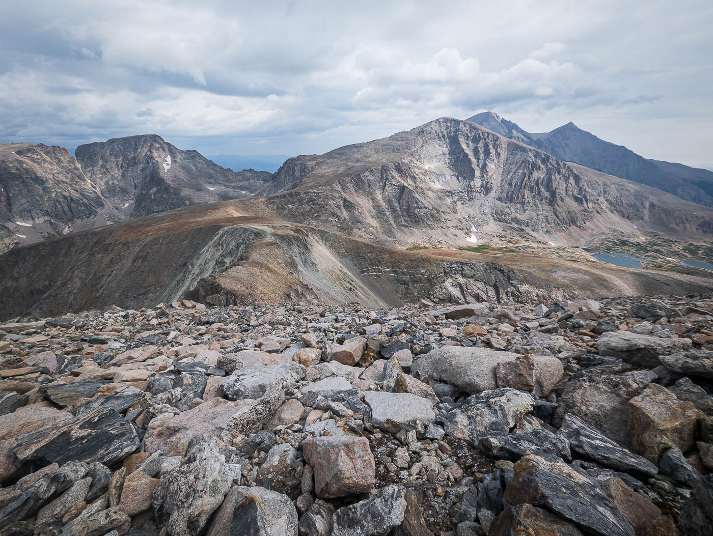
Mount Alice seen across the lake. The trail ascends the slope in the center.
Wider shot of Chiefs Head Peak (right) and Mount Alice (left).
View back toward Lion Lake #1.
Slightly more difficult to follow the trail as it ascends past various waterfalls.
View back down toward Lion Lake #1.
Mount Alice seen top left from Snowbank Lake. We headed left from here up to the prominent sloped ridge on the left, leading to the center of this photo.
View back along the prominent sloped ridge.
Mount Alice ahead.
Mount Alice ahead.
Close-up toward Mount Alice's impressive east face.
View back along the sloped ridge.
Hourglass Ridge ahead, followed by the Class 2+ scramble up to Mount Alice.
Along Hourlgass Ridge, view toward Chiefs Head Peak (right).
A dip along Hourglass Ridge.
Initially Class 2 up the slope.
A bit more bouldery scrambling higher up.
View back down toward Hourglass Ridge.
More Class 2/2+ higher up.
Mount Alice summit, view toward Chiefs Head Peak, Longs Peak, etc.
Amanda scrambling up to the summit along the north slope.
Mount Alice summit, view west.
Close-up toward Longs Peak.
Mount Alice summit, view south toward Tamina Peak.
Along our descent from Mount Alice.
Boulder-Grand Pass ahead, Tamina Peak left.
Looking back toward Mount Alice as we head up Tamina Peak.
Approaching the Class 2+ Tamina Peak finish.
The scrambly bit near the summit of Tamina Peak. Mount Alice seen top right.
Isolation Peak view from Tamina Peak.
Lake of Many Winds below, Longs Peak above.
The drop from Boulder-Grand Pass to Lake of Many Winds looks like horrible hardpan from above, but after the first short stretch, we were able to hop over the rib in the center and descend more safely.
View back up at the descent from Boulder-Grand Pass. The horrible hardpan is visible on the left, Amanda seen coming down on easier terrain.
View back toward Boulder-Grand Pass from Lake of Many Winds.
Descending the Boulder-Grand Pass trail.
Another shot back up toward Boulder-Grand Pass.
Gorgeous, lush trail as we descend below treeline.
Thunder Lake, view toward Mount Alice.
Lots more hiking through forest to return to the trailhead.

Hire me or show me some love!

Hire/refer me as a web developer or send me a few bucks if you find my site useful. I’m not sponsored, so all fees are out-of-pocket and my time preparing trip reports is unpaid. I really appreciate it!