Mount Russell via North Fork Lone Pine Creek in Sequoia National Park, CA

Hike Mount Russell via North Fork Lone Pine Creek Sequoia National Park, CA

Class 3 9.8 miles 5800 gain 8-11 hrs Out + Back Jul 26, 2025
Effort
Beauty
Personality
Solitude

Mount Russell via North Fork Lone Pine Creek GPX Track

I need to offset my substantial website costs somehow! You can download a hike/drive GPX to assist you here. Before sharing my GPX tracks with others, please remember my site is otherwise a free resource.

Jul 26, 2025 — Mount Russell is California’s seventh-highest peak, a 14er famous for its classic Class 3 scramble along the east ridge. Because it sits within the Mount Whitney Zone, both day trips and overnights require permits. Those are notoriously tricky to get, but since Christian and Woody managed to snag one and invited Matt and me along, that’s the only reason I ended up chasing this peak. I doubt I’d have gone through the trouble otherwise, with so many other worthwhile peaks in the Sierra. While Russell draws plenty of climbers on its own, its approach doubles as the route for the Mount Whitney Mountaineers Route, so we crossed paths with a slew of backpackers heading for the highest point in the lower 48.

We started from Whitney Portal, admittedly later than we should have so it was already really hot out. The first mile along the mellow, foot-highway Whitney Trail, but soon enough we turned onto the North Fork of Lone Pine Creek. From the very first steps up, the grade steepened, and it became clear I wasn’t remotely acclimated. This was shaping up to be one of my roughest-feeling mountain days in memory.

At first the trail climbed steeply but clearly through forest, then pushed into the North Fork drainage where brush crowded the creek between huge, high-angled slabs on either side. Approaching the famous Ebersbacher Ledges, the trail became narrower and momentarily harder to follow. We scrambled up some Class 2/2+ terrain out of the drainage to reach the ledges, which made for an enjoyable zig-zag scramble up the north wall of the drainage.

Above the ledges, the trail pressed on steeply toward Lower Boy Scout Lake. Once the lake came into view, we crossed the creek and skirted its south side, though a tempting false path heads around the north side. The route skirted a broad boulder field, staying low before near the edge of the lake before climbing to a brushy slope. Here the trail was faint and braided, but most options likely lead to a broad granite slab where the creek cascaded down. It was visible the whole time, so even if we’d missed the cairned turn-off, reaching it wouldn’t have been too troublesome.

Before reaching Upper Boy Scout Lake, we spotted a social trail cutting toward a steep sandy slope on Russell’s southeast flank, though the peak itself still hid out of sight. Up we went. The slope steepened into a sandy slope, views broadened, and the effort turned into a straightforward but energy-sapping slog. Coming back down later, though, it would prove to be a delightfully fast undertaking.

After nearly 1,500 feet of this slog, we topped out on a rim where Mount Russell finally revealed itself, jutting up at the end of a rolling sandy slope. To the west, Mount Whitney rose massive and imposing, together forming a glorious backdrop.

We gained the east ridge of Mount Russell on Class 2 terrain, following it until it abruptly steepened. From here, we kept mostly just below the crest but always above a dramatic drop-off on our right. The ridge offered a mix of solid rock, a handful of fun Class 3 moves, and a few airy stretches that kept things interesting without ever feeling sketchy.

Just below Russell’s east false summit, the ridge pinched into a steeper, more complex section that required some route-finding to keep the ascent Class 3. The grade steepened to gain the east summit, where keeping left of a rib and vertical crack kept at Class 2. From the false summit, we expected the traverse to the true high point to be gnarlier than it was, but it turned out to be a straightforward finish that followed ledges and blocky scramble bits.

PEAKS ON HIKE
Elevation (ft) / Prominence (ft)
Peaks on hike
Elevation
Prominence
1
Mount Russell - East Peak
14085 ft
43 rise
2
Mount Russell
14089 ft
1105 rise

Hire me or show me some love!

Hire/refer me as a web developer or send me a few bucks if you find my site useful. I'm not sponsored, so all fees are out-of-pocket and my time preparing trip reports is unpaid. I really appreciate it!

Whitney Portal.
Whitney Portal.
Along the Mount Whitney Trail for a short time.
Junction along the Mount Whitney Trail, where we took the North Fork Lone Pine Creek Trail.
View back along the trail, which is easy to follow most of the time.
The North Fork Lone Pine Creek Trail gets tricky to follow as it crosses the brushy creek and approaches the Ebersbacher Ledges, seen ahead.
Ascending from the drainage up Class 2+ terrain to gain the Ebersbacher Ledges.
Navigating the Ebersbacher Ledges above the creek.
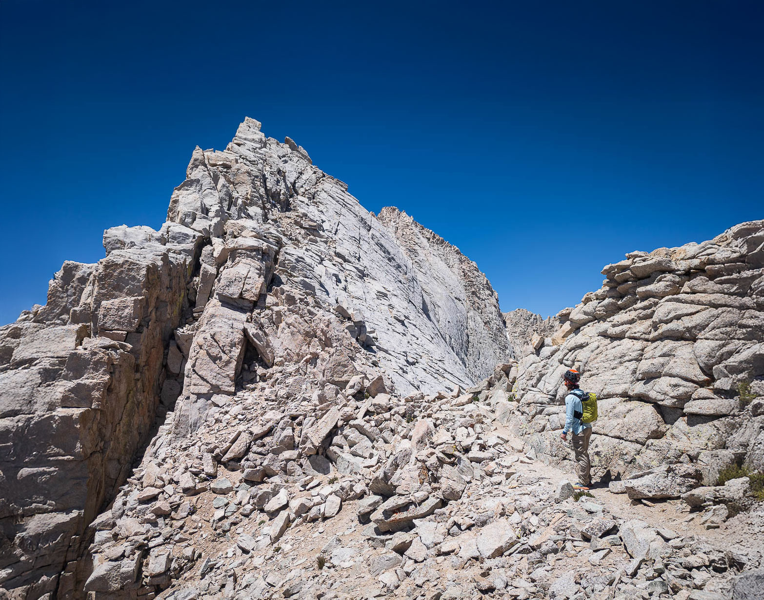
The Ebersbacher Ledges lead to higher ground above the drainage.
Ascending along the North Fork Lone Pine Creek Trail to Lower Boy Scout Lake.
Lower Boy Scout Lake just ahead. The trail crosses the creek and continues on the lake's south side. Mount Whitney's ridgeline is seen above.
The trail leads through a boulder field. Lower Boy Scout Lake seen below. Seen here is us off-route, but we managed to find the trail on the way back, reflected in my map/track.
Again the trail becomes a bit trickier to follow as it crosses the watercourse and ascends slabs of granite.
Ascending granite slabs, with a beautiful cascade rushing down as we enter the official Whitney Zone.
View back down the drainage.
Before reaching Upper Boy Scout Lake, we took a somewhat obvious social trail leading north toward the steep, sandy slope seen ahead.
Not a super fun ascend, but coming down later was excellent and quick.
View back down into the North Fork drainage as we make progress up the sandy slope.
Close-up back down at the annoying slog so far.
More progress up the sandy slope, as we near the rim.
Steeper still as we get higher.
At the rim, Mount Russell becomes visible (right of center).
Close-up of Mount Russell. It's a bit of a walk along a gradual slope.
Mount Whitney seen to the west.
Mount Whitney (left) and Mount Russell (right).
Approaching the east ridge.
Mount Russell east ridge, view toward Tulaino Lake.
View back from the east ridge along the slope we just hiked up (from the top left).
Starting up Mount Russell's east ridge. Class 2 for the first few hundred feet.
View back as the route becomes more interesting.
Approaching the famous scramble. The route leads above the steep dropoff, but just below the crest itself.
Along the ridge, just below the crest.
View back, the severe dropoff seen left. Tulaino Lake seen left.
A Class 3 move to get closer to the crest.
Just bouldery scramble moves along the crest for a while.
We only gained the crest for a few feet before it became sketchy, forcing us back just to the right.
Avoiding the jagged crest, traversing above the slick dropoff.
Wider shot of the ridgeline to come.
View back down.
View back down.
Wider shot back.
Wider shot back.
A Class 3 move with exposure to overcome a flake.
A short section of ridgeline like this, followed by a slightly more complex section of Class 3.
The ridgeline continues to be jagged, but now the terrain to the right becomes blocky and exposed. Also to note: ahead in the center is a vertical crack. The route leads to the left of it and its adjacent rib (Class 2), though ascending to its right is Class 3/4.
Class 3 route-finding to pick the best route for 50 feet.
Ascending the Class 2 option mentioned earlier, view back along the ridgeline.
Summit of Mount Russell's east peak, continuing west.
View back toward the east peak.
Navigating some Class 2/3 ledges and blocks to traverse over to the high point.
Mount Russell summit ahead. We approached it by wrapping around on the right, Class 2/3.
Mount Russell summit, view west.
Mount Russell summit, view south toward Mount Whitney.
Mount Russell summit, view northwest.
Close-up northwest.
Close-up northwest.

Hire me or show me some love!

Hire/refer me as a web developer or send me a few bucks if you find my site useful. I’m not sponsored, so all fees are out-of-pocket and my time preparing trip reports is unpaid. I really appreciate it!